Etruscan Phrases "F"
(continued)
by Mel Copeland
(from a work published in 1981)
Trade Routes
Trade routes tend to reflect migratory paths. From 10,000 years ago until today, the geography of the region from China to the Black Sea and the entry of the Danube river (above the Crimea) encourages certain paths for cattle and people to follow and discourages other routes. The Silk Road from China to Tehran or Damascus reflects not only the best travelled route to China but also the most practical route. Caravans required provisions and pasture. Provisions could be traded for in towns along the way for both man and beast. A traditional example would be the trade-routes to the American West. Traders carried beads, blankets, knives and axes to trade with the American Indians along the way to the Pacific Ocean in exchange for furs and other commodities which could be consumed or returned to the American states. In like manner there was a trade from Europe to Asia. Moving in long ships from the Baltic Sea, Vikings in the 11th century A.D. travelled down the Volga to the Caspian Sea, trading for furs and establishing trading posts such as St. Petersburg to Astrakhan on the Caspian Sea. Europeans wishing to trade further south would proceed down the western coast of the Caspian Sea to a point half way down the coast called the "Caspian Gates," mentioned by Bacon, above. Marco Polo later described these as the "Iron Gates." The Iron Gates represented a defile in the place now called Derbent, Russia. Here, north of Baku, which is now in Azerbaijan, the Caucus Mountains dive into the coastline, leaving a narrow passage. The passage was controlled through fortifications and (toll) gates. Armies from one nation after another attempted to control these gates. The town is 5,000 years old. You can see and read more about it at: http://www.towns.ru/towns/derbent_e.html.
If one were not able to get through Derbent, one would have to go north of the Caspian Sea through the Kirghiz Steppes of Kazakhstan (which would have required the permission of the Khazar Khan, another problem). Prior to the Khazars, the territory was held by the Scythians: from the Dneister river along the northern side of the Carpathian mountains, and the Crimea, northward to the Don river and southward to the Caucaus Mountains and the Caspian Sea. These horsed nomads were so powerful from about 700 B.C. nations feared their raids, for they made much of their livelihood in capturing towns and peoples. They traded in slaves through the Black Sea ports with the Greeks, and those slaves whom they kept for themselves they blinded. They grew grain and shipped wheat, flocks and cheese to Greece. They are known for their excellence in working gold and silver and the hordes they left in tombs (barrows) of their heroes. They also scalped their enemies and used the dressed scalps as napkins, leaving them to hang from their belt. The men did not cut their hair or beards, wore pointed helmuts and though they made bits for their horses they did not have saddles. A group of the Scythians, identified as the Amazons, were known for their womens' ability to fight and ride. Their women are said to have had their right breasts cauterized in youth, to prevent growth, so that they would make fine archers. Related to them were the Sarmatians who occupied the Russian steps northward to the Ural Mountains. Another group of Scythians, the Royal Scythians, roamed the Asian steppes to the Altai Mountains, which may have been their homeland sanctuary, north of the junction of the Kazakhstan / Chinese / Mongolian borders. The site at Pazyrk suggests that their origins were in Western Siberia before they moved eastward to the Black Sea. A recent tumulus found at Kyzyl, the capital of the western Siberian republic of Tuva, revealed almost 5,000 decorative gold pieces that adorned the bodies of a man and woman dating from about 600 to 500 B.C. What is remarkable about the 44 pound treasure is the fact that the design of the pieces predates Greek influence. Scythian jewelry in the West is influenced with Greek designs. This find was reported January 9, 2002 and may be seen at: http://www.fotuva.org/history/archaeology.html.
The Western branch of the Scythians turned back Darius by the Caspian Sea. Herodotus reports the incident, how the Scythians pointed out that Darius, about 513 B.C., was wasting his time fighting them, since they had no cities to conquer. While the frustrated Persian army hoped to enjoin battle the bored Scythian warriors happened to see a hare and broke ranks, giving chase to it. Darius gave up the effort. Herodotus may be read in Greek and English at the following link: http://herodot.glossa.dk/hdt4.html. Most of what we know about the ancient Scythians is from Herodotus.
While it is commonly believed that the Scythian language was Indo-European, related to Ossetic — a Persian language close to Avestan — Mirfatykh Z. Zakiev argues at http://www.turkicworld.org/ that the Scythians were Tartars. He offers an impressive, detailed discussion on Turkish roots, but loses credibility with me when he suggests that the Etruscans spoke a Tatar language. Good links through which to explore the Scythians are:
http://www.encyclopedia4u.com/scythia.html (now a dead link);
http://www.pbs.org/wgbh/nova/transcripts/2517siberian.html – the Nova report on the Tocharian mummy;
http://www.turanianhorse.org/scythians.html –the key to the Scythians is their horsemanship.
http://www.studentorgs.utexas.edu/husa/origins/szkitahist/szkitaart.html (now a dead link)
The Cimmerians, who resided in the Crimea and north of the Black Sea, and are believed to be related to the Thracians, were disbursed by the Scythians. Some reports suggest that the remnants of the Cimmerians ended up in Britain. Cappadocia, a region in the center of Turkey, is called Gimer in the Armenian language, and this may be the final residence of the Cimmerians. A western branch of the Cimmerians, pressured by the Scythians, moved into the Hungarian plain and survived there until 500 B.C.
Perhaps the only ones who took the route between the Black and Caspian seas, besides armies like Alexander's and Darius' — both of whom were blocked at the Iron Gates — were people who would trade for Scythian goods. But the main route to Asia was from Aleppo to the Oxus river, south of the Aral Sea and following the Oxus river east would take you to India, according to Herodotus. The Silk Road by and large led from Tehran or Damascus to Mirv,and from Mirv one could proceed northeast to Bukhara and then to Samarkand. From Samarkand there seems to have been two parallel routes into China. The northern route would lead to Turfan and Hami and then southeast to Dunhuang. The southern route would go through Yarkand, Khoian, Cherchen and northeast to Dunhuang. From Dunhuang the road led southeast to Lanzhou and Chang'an (the name we now know as China). The northern route is the one Marco Polo is believed to have taken. But he began his journey from the Crimea, to which he sailed. He traveled into Tartar (Tatar) territory to the Volga above the Caspian Sea and passed between the Caspian Sea and the Aral Sea to the Oxus River, crossing it and entering Bukhara.
A passage north of the Aral Sea would lead into swamps called the Maeotic Swamps. The Aral Sea and the Swamps were like guide-posts (to avoid) along the route, and Chinese geographers suggest that the end of the Western World is at those swamps. Herodotus reports that the Scythians reported that there was nothing north of them and that anyone going north towards the Urals would be blinded by "feathers."
Chinese accounts from 91 B.C. to 1643 A.D. can be read at the Medieval Sourcebook: http://www.fordham.edu/halsall/eastasia/romchin1.html. A map of Marco Polo's route, which led from the Volga to the Oxus river and beyond can be seen at: http://silkroadfoundation.org/maps/images/polomap.jpg. Mountain passes, swamps and deserts pretty well constrain one's passage from Asia to Europe. The routes of the Silk Road can also be viewed at the Silk Road Foundation site.
10,000 years ago the areas which are now desert were more temperate, and this is not only evident in the Sahara and Middle East but also near the Iron Gates of the Caspian Sea. South of the gates, a few miles south of Baku at a place called Gobustan, are rock engravings dating from 10,000 to 8,000 years ago. Some of the engravings are reliefs and they show cattle, two-wheeled carts, lions, and other animals of a more temperate climate. The region is now arid. Many of these engravings can be viewed at http://www.hominids.com/donsmaps/gobustan.html. Ancestors of the Indo-Europeans may have been growing crops and raising cattle in this once luscious place, and it may very well have been the entry to a passage south of the Caucus Mountains to the ancient town of Colchis on the Black Sea (The passage south, between the Caspian and Black Seas, may have been facilitated at that time by the presence of a waterway, from an expanded sea environment – could they have travelled from the Black Sea to the Caspian Sea by boat?). Colchis is the ancient place in the story of Jason and the Argonauts where Jason took the Golden Fleece, and it is also near the place in the Caucus Mountains where Prometheus was bound and tormented. According to the Encyclopedia Britannica Prometheus was
"one of the Titans, the supreme trickster, and a god of fire. His intellectual side was emphasized by the apparent meaning of his name, Forethinker. In common belief he developed into a master craftsman, and in this connection he was associated with fire and the creation of man.
"The Greek poet Hesiod related two principal legends concerning Prometheus. The first is that Zeus, the chief god, who had been tricked by Prometheus into accepting the bones and fat of sacrifice instead of the meat, hid fire from man. Prometheus, however, stole it and returned it to Earth once again. As the price of fire, and as punishment for mankind in general, Zeus created the woman Pandora and sent her down to Epimetheus (Hindsight), who, though warned by Prometheus, married her. Pandora took the great lid off the jar she carried, and evils, hard work, and disease flew out to wander among mankind. Hope alone remained within.
"Hesiod relates in his other tale that, as vengeance on Prometheus, Zeus had him chained and sent an eagle to eat his immortal liver, which constantly replenished itself."
The Black Sea region played a central role in the creation myths of the Greeks. Also, it played a special role in the heroic myths of the Greeks and many other peoples, particularly with regard to the almost universal hero, Hercules. His role is also prominent in the Etruscan mythology. To view the entire Black Sea and Caspian Sea region from space, as well as other areas, go to Visibleearth/nasa.gov: http://visibleearth.nasa.gov/view_rec.php?id=6488— Caspian Satellite image.
An informative study on how people choose sites from an agricultural point of view is offered by T. H. van Andel and C. N. Runnels in their article, "The Earliest farmers in Europe," http://www.unige.ch/lettres/archeo/introduction_seminaire/neolithique/runnels.html. River valleys offer perfect places of habitation for settlements — usually on top of river banks – in their floodplains, and another place to locate is on lake shores. Lakes formed by rivers or natural springs offer ideal places in which to grow crops, as well as to fish. The Balkans, as pointed out by van Andel and Runnels, offer great resources for immigrants. It was a great place, in the neolithic and continues to be treasured to this day.
Settlements become market places for the inhabitants of a region and the larger settlements, being wealthier as it were, became centers of international trade, places where trade routes led. Gobustun offered a good place to settle, on the shores of the Caspian Sea, and we can see that those who settled in that place were maritime, using long boats, no doubt engaged for fishing, but serving as well for military applications. Other sites from the tell — a tell is a mound built up from the deposits of a city building atop its own refuse of thousands of years — of Jericho to Thebes, Egypt, to Babylon and the tell of Vinca were located along river banks, risking the floods but reaping the benefits of the alluvial deposits.
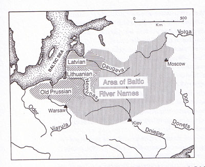
Rivers, of course, were the main courses through which people moved, and as a people move into a territory, conquering an indigenous group, the names of the rivers are changed by the new occupiers of a region. For instance the region north of the Black Sea encompassing the rivers (from east to west) Don, Donets, Dnieper and the lower reaches of the Dniester are believed to be Iranian names.
 |
|
Distribution of Baltic river names versus Persian river names, Don, Donets, Dneiper, from Mallory, "In Search of the Indo-Europeans."
|
Claims as to who was first among the Indo-Europeans
There seems to be a reawakening of national identity today as a result of the breaking of the shackles of the Soviet Empire. People who speak the Slavic language, such as the Macedonians and Thracians, are examining their pre-Slavic origins. The Turks are exploring whether there was a Tartar (Tatar) presence in Europe before the Huns. The world is retribalizing, as it were, from the American Indian tribes to the ancient tribes of Europe and Asia. An discussion having to do with the Magyar origins is at http://groups.msn.com/AncientWisdomCulturesPeople/magyars.msnw. It relates myths on the foundation of the various Turkish tribes.
A study, from the Indian / Sanskrit point of view, by Gaurang Bhatt, MD, whose site is Boloji.com, proposes: "Proto-Indo-European, the Mother of Languages." Sanskrit appears to be the oldest written form of the Indo-European languages, and thus the place to look for the Mother of all Languages, so the theory goes. Another study, by Asiff Hussein," Sinhala, 6000 years ago," compares the phonetic changes of other Indo-European languages to Sinhala.
A Macedonian argument, http://www.historyofmacedonia.org/AncientMacedonia/AncientEvidence.html, points out that Alexander the Great and his father, Philip II of Macedon, were not Greek and spoke a language which was not Greek. The argument leads to the conclusion that the empire of Alexander the Great was not Greek but Macedonian. What could be said about the argument is that the Macedonians did in fact create the empire, but the empire adopted the culture and language of the Greeks. The Macedonians, like the Scythians, who conquered the Near East as far as Palestine, and the Mongols, who conquered from China to Poland, could not sustain their empire without adopting the cultural trappings of those whom they conquered. The Chinese have always pointed out that though Ghengis Khan may have conquered them, within a few generations the Mongol administrators had become absorbed as Chinese. The Mongols had an alphabet created through which to communicate their language, but they in due time deferred to the established Chinese system and culture.
The history of the Thracians is worth checking out for many reasons. Thracia (Herodotus puts the island of Thasos, Thessaloniki, in Thracia) is now the focus of much archeological investigation, for it is now starting to reveal the treasures of the Scythian-like tombs in its heart-land — including Macedonia and Bulgaria. A site, http://www.dacia.org/history/trdac_e.html, advances the argument that Thracia is the center from which the Indo-Europeans spread. To appreciate the richness of the Thracian tombs, go to: http://www.athenapub.com/thrace1.htm.
It is believed that the Phrygians, another Indo-European people, who entered Anatolia about 1,200 B.C., came from Thrace. Research suggests that the Phrygian language is close to Armenian, and their inscriptions date from the 8th century B.C. to the 3rd century A.D. Their dominion was broken by the invasion of the Cimmerians in the 7th century B.C., and in the 6th century B.C. Croesus, king of Lydia, brought them under his rule. Hissarlisk, a site guarding the Dardanelles, leading into the sea of Maramara and the Black Sea, was part of the Lydian dominion. It was the tell of Troy, level VIIb, which is believed to be the city of the Iliad. It was destroyed about 1180 B.C., essentially the same time as the Hittite empire collapsed, and also when Egypt was invaded by the "Sea Peoples." The pottery style of Troy at that time, called Grey Minyan, is identical to the style of Greek pottery of that time in Larissa, Greece. About the time the Illyrians were invading Anatolia, Troy VI (1,900-1,275 B.C.), showed a new benchmark in Trojan culture with the introduction of the Grey Minyan ware. The same invaders who brought Grey Minyan ware to Greece are believed to have brought it to Troy VI. These invaders are believed to have spoken the Greek language. Also in Troy VI for the first time are the bones of the horse. Troy VI appears to have been destroyed by an earthquake. About 1,100 B.C. the city was rebuilt, only to be devastated by fire shortly thereafter. If the Grey Minyan ware people in Troy spoke Greek, then the Trojan war was between Greeks, a conclusion which does not seem to be supported by the Iliad and the non-Greek character of the Lydian language.
Among the Thracian peoples were the Triballi who appear to have lived on the Plain of Kosovo, near the junction of the Angrus and Brongus rivers. About 424 B.C. an Illyrian tribe, the Autariate, overcame them. The Illyrians were of Indo-European stock who settled, beginning about 1,300 B.C., the northern and eastern coasts of the Adriatic Sea. Their tribes include the Dalmatians and the Pannonians, and those of them who settled in south-eastern Italy, beginning 1,200 B.C., were the Messapians. At the northeastern corner of Italy, including parts of Austria and Slovenia, were the Veneti. One of their principal cities was Spina, which is recorded in the Etruscan texts, in the Vocabulary below. While the Thracians controlled the Balkans, it is clear that they were being challenged from the Adriatic coast and also from Greece / Macedonia. Thrace was well known for its silver and gold mines. Philip II captured the Pangeion gold mines of Thracia near the Strymon delta in 348 B.C., and the abundance of tombs, some with Etruscan-like entrances and murals, testifies to the power of their culture. The tombs concentrated in the area may also reflect a holy burial ground of the Thracians.
About 339 B.C. the Triballi had a hand in changing history, as it were, as they refused to allow Philip II of Macedon to pass through the Haemus (Balkan) Range because he refused to share his booty with them. In forcing his passage Phillip was wounded; but after his death in 335 B.C. his son, Alexander the Great, crossed the Haemus and defeated the Triballi.
The Thracian region is important not only from the stand-point of understanding western history but also it can help explain the movement of Indo-European peoples. For in the Danubian heart-land is a tell called Vinca, which shares, along with the tell of Çatal Hüyük in Turkey and the tell of Jericho in Israel, the distinction of being the places — shared with Sumer and Egypt – where western civilization began. Vinca has a particularly important relationship to the Villanovan culture in Italy. The oval huts described in the Vinca settlements recall the Villanovan funerary urn noted above. These homes also reflect the style of the Alpine Swiss lake dwellers. Vinca burial urns, though perhaps earlier than Villanovan, share a common feature, where the lids of the burial urns contained anthropomorphic faces. These "face urns" were also in use in Troy III dating 2,300-2,200 B.C. To explore Vinca go to: http://groups.msn.com/AncientWisdomCulturesPeople/vincaculture1.msnw.
The site of Vinca on the Danube river is the first evidence of the construction of tells in Europe. If the Etruscan peoples were refugees fleeing Lydia after the Trojan war, as their mythology purported, they could have entered Italy by sea or migrated up the Danube through Vinca, on to Austria, and crossed over the Alps into northern Italy, establishing, through either or both routes, the Villanovan culture. Not to confuse the matter, but Vinca guarded the northern route of the Danube river, where the river flows through a deep gorge called the "Iron Gates" (often confused with the Caspian Iron Gates). Keeping in mind that the period of the migration, about 1,100 B.C., marks a "Dark Age" where in the remnants of the Mycenaean civilization open cities became fortified hill-top towns and coasts from Egypt to Anatolia, Illyria, Italy and Spain were under siege by pirates called "Sea Peoples." The Sea Peoples, according to Egyptian records, include the Sardinians (Shardana), Sikels (of Sicily), Pulusti (Philistines) and the Tyrni (a people believed to be the Etruscans who were called by the Greeks as Tyrrhenians or Tyrrhenoi; the sea adjacent to western Italy is called the Tyrrhenian Sea).
The Albanians may offer some clue to the early inhabitants of the region which is traditionally considered the Indo-European homeland above the Black Sea. A commentary on this is at http://www.bakililar.az/ca/eng/history/caspian.html. A comparison of toponyms between villages in Albania and the Caucus region is at: http://www.geocities.com/CapitolHill/Lobby/7681/albanian_toponyms.html. Maps can be found through the centuries showing Albania covering a great part of the Black Sea region, west and north of Anatolia.
An argument on the antiquity of the Serbs who, the author proposes, did not speak Slavic, is at: http://www.geocities.com/CapitolHill/Lobby/7681/origins.html. As I understand it, the Serbian argument proposed here is that the Serbian language was originally an early Indo-European tongue which is closer to German than Slavic. Incidentally, Serb scholars have suggested that the Etruscans spoke the "Serbian" language. The Serbian alphabet uses characters common to the Etruscan alphabet. The Runes used by the Germanic tribes, including the Scandinavians, also share characters common to the Etruscan alphabet. The runes antedate the Etruscan alphabet, however, by about 800 years.
Mounds, dolmens and stone alignments as early as 3,000 B.C., from the Black Sea to Italy, Iberia and thence to Britain, remind us of a culture which may have been linguistically diverse yet somehow related, probably Indo-European. We are compelled to compare the Celts and the Italic clans. Early Italic peoples in Northern Italy traded in flints and metals across the Alps, where mining, as in Innsbruck, Austria, was abundant, and flint was abundant in Italy. Mining has always been a means, or more appropriately, object, through which cultures have spread. One can follow the trade of flints, the trade of tin, first by the Akkadians who sought tin from Anatolia to manufacture bronze; Innsbruck was a source of tin and no doubt the Thracians guarded rich sources of tin; and finally Wales and Cornwall became exploited for tin. The control of precious metals has been the objective of great armies. And it may, perhaps, be fitting to end this section with the Celts, who may have been involved in the trade of metal from the Black Sea to the British Isles. The Celts were called "Galli" by the Romans and "Galatai" or "Keltoi" by the Greeks. The term, "Keltoi," means "barbarian." The pronunciation of the "c" in Celt is with a "k"; the soft "c" sound in Celtic came about under the British Empire.
The Celts appear to have landed in Britain in two "waves." The earlier form of the language is closest to Italic, the precursor of Latin. Says "Neander97's Historical Trivia,":
"The original wave of Celtic immigrants to the British Isles are called the 'Q-Celts' and spoke Goidelic. It is not known exactly when this immigration occurred but it may be placed sometime in the window of 2,000 to 1,200 B.C. The label Q-Celtic stems from the differences between this early Celtic tongue and Italic. Some of the differences between Italic and Celtic included that lack of a 'P' in Celtic and the Italic 'O.'
"At a later date, a second wave of immigrants took to the British Isles – a wave of Celts referred to as the 'P-Celts' speaking Brythonic. Goidelic led to the formation of three Gaelic languages spoken in Ireland, the island of Man and later Scotland. Brythonic gave rise to two British Isles languages, Welsh and Cornish, as well as one surviving one the Continent in the form of Breton, spoken in Brittany.
"The label 'Q-Celtic' stems from the differences between this early Celtic tongue and the latter formed 'P-Celtic.' The differences between the two Celtic branches are simple in theoretical form. Take for example the word ekvos in Indo-European, meaning 'horse.' In 'Q-Celtic' this was rendered as equos while in 'P-Celtic' it became epos, the 'Q' sound being replaced with the 'P' sound. Another example is the Latin 'qui,' 'who.' In 'Q-Celtic' this is rendered as 'cia,' while in 'P-Celtic' it is rendered as 'pwy.'"
Because the British Isles were a point of convergence of many groups of Indo-Europeans, their inhabitants over the centuries reflect what can happen in the diffusion of languages. A good resource on the history of the English language is at http://www.anglik.net/englishlanguagehistory.htm.
Etruscan — Its place in the Indo-European sequence
We cannot say that Etruscan is older or younger than Latin. What we do know and can say is that the Etruscan civilization pre-dated the Latin (Roman) civilization and gave to Rome the foundations of its culture and writing system. By 800 B.C. the Etruscans had made their imprint on the map of Italy; by 600 B.C. the 12 Etruscan city states were rivaling the 12 Greek city states and began writing. The Etruscan mythology (according to Roman historians) included a belief that their civilization had migrated from Lydia (Anatolia) and would last a thousand years. As it turns out, early archeological records tend to support the flowering of the Etruscan culture ~1,000 B.C., and it ended about 100 B.C., one thousand years later. When Iron became the preferred metal, first used by the Hittites, the masters over the Iron mines and the routes to them became dominant powers. In the western Mediterranean the iron mines and the routes to them were controlled by the Etruscans. According to the Encyclopedia Britannica:
"The date of the full Iron Age, in which this metal for the most part replaced bronze in implements and weapons, varied geographically, beginning in the Middle East and southeastern Europe about 1200 BC but in China not until about 600 BC. Although in the Middle East iron had limited use as a scarce and precious metal as early as 3000 BC, thereis no indication that people at that time recognized its superior qualities over those of bronze. Between 1200 and 1000, B.C., however, the export of knowledge of iron metallurgy and of iron objects was rapid and widespread."
At the beginning of the Iron Age, the emergence of the Etruscans can be reconciled to the practice of cremation. Says Massimo Pallottino, The Etruscans, translation, Indiana University Press, 1975, p. 45:
"The establishment of the rite of cremation seems to have been accompanied by new cultural features, for it coincides with the spread of certain vase forms (especially the biconical ossuary), of a number of new decorative motifs on pottery, and of some bronze types also found in isolated hoards and settlement sites. As a result we can now talk in terms of a true archeological culure, perhaps even of a chronological phase, called 'Protovillanovan.' We can now be certain — and this is of fundamental importance — that the Protovillanovan phenomenon spread over the whole Italian area, from Apulia (Timmari) and Sicily (Milazzo, Lipari) to the west coast of the peninsula (Sasso and Allumiere in the Tolfa hills, Palombara Sabina, Ponte San Pietro near Vulci, Monte Argentario, Sticciano north of Grosseto, etc.) to the Adriatic coast (Pianello della Genga in the Marche) and to the north (Bismantova, Fontanella Mantovana — where, however, the phenomenon is somewhat different from the cremation cemeteries mentioned above). What characterizes the Protovillanovan is the singular uniformity of its maqnifestations in places far distant from each other, a probable indication that there were close and rapid communications. Within the Etruscan area, Protovillanovan communities seem to have lasted until the beginning of the Iron Age and to have been, in a sense, absorbed by the Villanovan civilization of the great coastal centres that in turn were to become the cities of historical times. Elsewhere, in Latium (Rome, the Alban hills), in Umbria (Terni) and in the Po valley (Este), the local versions of the Iron Age spring directly from types of culture that are Protovillanovan in character; these may be usefully labelled 'Proto-Latial,' 'Proto-Umbrian,' 'Proto-Atestine' and 'Proto-Golaseccan.'
"A clear differentiation into regional cultural groups becomes apparent only with the beginning of the Iron Age proper. This can be recognized by the spread of the use of the new metal and the general adoption of linear decorative styles, coinciding with the flourishing of the Geometric style in the Greek world, from about the ninth century B.C...The following regional groups may be distinguished: the cultures of Sicily; the southern cultures of Calabria and Campania; the Adriatic cultures of Apulia, and of the Samnite and Picene areas; that of Latium; the Villanovan cultures of Etruria and Emila (with related groups in southern and Adriatic Italy); the northern cultures of Este (the Veneto), Golasecca (Lombardy, Piedmont) and Liguria. These groups can be divided roughly into two large areas according to the use of inhumation or cremation as a burial rite. The inhuming area comprises southern Italy and the lands bordering on the Adriatic; the cremating area covers Latium, Tuscany, part of Umbria and the whole of northern Italy...The geographic separation of burial rites is one more indication that the Iron Age was accompanied by the definition and fixation of traditions which were still fluid in the preceeding ages."
The Etruscans represent a watershed, of a transfer of power from Bronze Age dominions to new Iron Age dominions. The ProtoEtruscan culture is one which is deeply rooted in Greek and Anatolian / Black Sea culture(s), and it is clear that illuminating them will shed light on the history of Eur-Asia.
There is no question about the dating of the ProtoEtruscan culture, and the relationship between the Celtic and ProtoItalic languages. Because it is clear from Table 1 below that Etruscan bears a strong resemblance to Latin, as well as Celtic, it forces us to reconsider the placement of both languages in the diagram of the Indo-European languages. And we may very well learn a bit more about the Macedonians, Thracians and Scythians, the Illyrians, the Lydians, the Phyrigians and the Albanians.
The Slavs are another group whose origins no doubt will be better illuminated. They certainly became the dominant language group of Eastern Europe, withstanding the pressure of laterTurkish and Gothic invaders.
The source(s) of the Indo-European language group are believed to be in Anatolia or north of the Black and Caspian seas. Some scholars in India controvert this theory, that Sanskrit is the mother tongue of the Indo-European languages. Another theory suggests that the Proto-Indo-European tongue would have lacked the "b," a thesis which would place the Etruscan vocabulary in greater light, since the Etruscan vocabulary reflects a shift from "b" to "p." Other characteristics found in the Etruscan language to date suggest that it may reside somewhere between Latin and Greek, and this seems to be accented by the strength of the 'f' and 'ph' sounds in Etruscan, the weakness of the 'd' in favor of the 't' and 'th.'
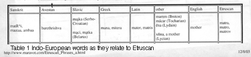
The following tables illustrate the relationship of the Indo-European languages based upon the word "hundred," whether it is spelled with a "c," i.e., centum, or "s", i.e., satem.
|
|
||||||||||||||||||||||||||||||||||||
How the Indo-European languages relate to one another based upon the word "hundred" may be too simplistic, and the outcome of the Etruscan vocabulary may affect this list. I have separated Etruscan from the Italic group of languages, based upon the relationships being discerned through Table 1. Some Indo-European root words as they may relate to Etruscan are indicated in Table 1: Indo-European words as they relate to Etruscan. I have broken Table 1 into a separate frame so that it may be viewed along with this source page. Sources used for compiling the table, in addition to this page for the Etruscan vocabulary (Etruscan, Latin, Italian and French), are as follows: The table shows 'markers,' word forms which can be traced from one of the formative Indo-European tongues to another. At this writing, 12.28.03, based upon the patterns in the table, I believe Albanian belongs in the Centum group of languages. From, and now supplemental to Table 1, we have an Etruscan Grammar and Etruscan Glossary, both available in html and Excel worksheets. The Etruscan Phrases Excel worksheets are the most current, from which the html pages will be updated.
Tocharian: http://www.omniglot.com/writing/tocharian.htm.
Sanskrit: Capeller's Sanskrit-English Dictionary
Avestan: http://www.avesta.org/avdict/avdict.htm, Copyright 1995, Joseph H. Peterson
Greek: http://www.kypros.org/cgi-bin/lexicon
Illyrian: http://www.geocities.com/indoeurop/project/glossary/illy.html. A useful bilbliography of that site (now dead) is as follows:
Sources:
1. Neroznak, V. Paleo-Balkan languages. Moscow, 1978.
2. Katicic, R. Ancient Languages of the Balkans. The Hague, 1976.
3. Fasmer, M. The Etymological Dictionary of the Russian Language. Moscow, 1986.
Albania traces its history to the Illyrian peoples. See http://www.albanian.com/information/history/origins.html.
Serbo_Croatian: http://www.recnik.com/.
Note that Serbian and Croatian are written in different scripts. Serbian uses an alphabet that is "mysteriously" similar to the Etruscan alphabet. I say "mysteriously," because the two writing systems are separated in time: Etruscan, ~650 B.C.-100 B.C.; Serbian, ~ 600-700 A.D. to the present. Thanks to the encouragement of my Serbian friend, Predrag Djordjevic, I am now looking closer into the connection of Serbo-Croatian to Etruscan. The Serbian script is probably more directly linked to the spread of runes among the German and Iberian peoples, and may be the source from which the runes spread. There is, however, a lead tablet from La Serreta de Alcoy (circa. 6th century B.C.) which uses characters similar to the Etruscan and appears to be early Indo-European, that refers to "Bask," emphasizes the "B" and begins: ReKeH (rege) QDITI: PARQ (parque) KAN: DADV LA: BASK PETIN HeR BATARQeK: (I will comment on this later).
The Croatian alphabet – from the same "Serbian language group"– is in the Roman style, from the Catholic heritage.
Belorus: http://www.ceti.com.pl/~hajduk (now a dead link), by Ryhor Hajduk; See the other translation service, slovnyk.org.
Polish: http://www.slovnyk.org. A special thanks to slovnyk.org for the thoroughness of their searchable dictionary which also contains Belarusan, Russian, and Ukranian.
Lycian: http://www.geocities.com/indoeurop/project/glossary/lyci.html (now a dead link) Bilbliographical sources from this site are:
Sources:
1. Ivanov V. The Hittite Language. Moscow, 1963.
2. Gamkrelidze T., Ivanov V. The Indo-European Language and Indo-Europeans. Moscow, 1984.
3. Bajun, L. The Experience of the Comparative Studies of Hitto-Luwian Languages. Moscow, 1990.
4. Bajun L. The Language of Hittite Hieroglyphs. Moscow, 1986.
5. Korolev, A. Hitto-Luwian Languages. Languages of Asia and Africa, vol. 1. Moscow, 1976.
6. Shevoroshkin, V. The Carian Language. Modern stage of development and studies. Matters of Indo-European Linguistics. Moscow, 1964.
7. Bajun L., Language relations between Phrygian and Anatolian. Moscow, 1989.
Breton: http://www.yourdictionary.com/languages/celtic.html
Gaelic: (Scottish) http://www.ceantar.org/Dicts/search.html
Welsh: http://www.geiriadur.net/
Click on Table 1 image for a complete view of the table.
Following the "markers" in this table reveals a footprint of the Etruscan language (as well as others related to it). What is particularly interesting is the correlation of Etruscan words to French, Gaelic and Sanskrit, without a tie to Latin. Etruscan seems to bridge as well between Greek and the Anatolian languages, particularly Lydian. The details of this correlation are yet to be reviewed, pending the development of this table. The groups chosen for comparison are based upon the criteria discussed above. The table is in several segments, reflecting several hundred words in the Etruscan Vocabulary below which agree with other Indo-European words (cognates). It is recognized by Indo-European scholars that two hundred words in a given vocabulary that are matches to other Indo-European languages would be sufficient cause to categorize a language as an Indo-European language. The Table is currently (2.29.04) up to Section 1F and is being organized alphabetically (by Etruscan) to include all applicable words of the Vocabulary below. The translations will be updated with the results or modifications discerned through Table 1.
The Vocabulary was used to build Table 1, with its various sections. Table 1, therefore, is the document [when it is completed] upon which one should rely in analyzing the Etruscan scripts: the meaning of Etruscan words and the relationship the vocabulary and grammar have to other Indo-European languages. Each section of the table has approximately 200 cognates of Etruscan words (that match up with nearly identically spelled words in Latin, Italian and French, and other Indo-European languages). Experts have maintained that 200 cognates in a language justify a relationship to another language. The data in this table exceed those requirements. The cognates that are colored red show a western (Latin) bias; those in blue show an eastern (Sanskrit) bias, and those in the middle (Black Sea/Germanic) I have colored green. The relationships are interesting. Etruscan, which is the most clearly Latin-biased language of the group, reconfirms, as a silent, unchanged partner from the past as it were, the dispersal of the groups as of 600 B.C. All of the other languages in Table 1 have experienced modification of one sort or another through its contact with the other language groups. Of those groups, Albanian seems to be the most consistent, reflecting a strong bias to the Germanic (English), and like English, reflecting the Latin influence. Ancient cartographers showed the Albanians residing in what is now Russia, on the northern side of the Caucus mountains, and it appears that this would have been the proper location for them, where they were centrally located between the westward moving Latin-like tribes and the eastward moving Indic tribes (Strabo placed the Albanians in this area, for instance). The Persians also seemed to have been wedged between the two groups (as they are to this day). In using Table 1 for purposes which go beyond understanding the Etruscan language, I would suggest that one examine the exceptional links, such as in the word "yoke" which is something all of the horsemen of the Indo-Europeans have been doing ever since they harnessed a horse to a plow or wagon. The English and Sanskrit word for "yoke" is almost identical; where we might expect the Welsh word to coincide with English it has a bias toward the Latin-Etruscan. Table 1 is not complete, of course, but it appears that there is a strong geographic correlation to the distribution of the languages using the mix currently being shown: the eastern group in blue, the western group in red, those in the middle, in green. Those in green appear to have moved up the rivers from the Black Sea into Europe; those in red appear to have moved by sea and by land, and those in blue went to the east. Why there is a crop of blue here and there in Table 1 needs to be explained.
The sources of English words noted in brackets [ ] are from The Concise American Heritage Dictionary, Houghton Mifflin Co., 1987. There are instances where the reader will find that Table 1 data would not be in agreement with the source in brackets.
Table 1
|
|
![]() Etruscan Glossary with link to Excel spreadsheet Etruscan GlossaryA.xls. (This spreadsheet is current.)
Etruscan Glossary with link to Excel spreadsheet Etruscan GlossaryA.xls. (This spreadsheet is current.)
![]() Etruscan Grammar with link to Excel spreadsheet Etruscan Grammar.xls. (not current, but will be updated)
Etruscan Grammar with link to Excel spreadsheet Etruscan Grammar.xls. (not current, but will be updated)
![]() To view the Etruscan alphabet as used in these scripts click here, Lemnos Script.html
To view the Etruscan alphabet as used in these scripts click here, Lemnos Script.html
![]() To the Vocabulary words > L, (no longer current; see Grammar and Glossary) which laid the foundation for Table 1.
To the Vocabulary words > L, (no longer current; see Grammar and Glossary) which laid the foundation for Table 1.
![]() To Vocabulary words L> (no longer current; see Grammar and Glossary)
To Vocabulary words L> (no longer current; see Grammar and Glossary)
(Etruscan_Phrases_d.html)
![]() Please beam me back up to Maravot's_Index.html
Please beam me back up to Maravot's_Index.html
Launched 7.26.98
Updated: 7.09.04; 7.12.04; 9.08.04; 10.15.05; 8.27.06; 12.04.06; 01.05.07; 1.29.07; 2.17.07; 2.23.07; 4.25.07; 5.08.07; 10.16.07; 1.07.08; 2.13.09; 8.16.09
Copyright ©1981-2009 Maravot. All rights reserved.
Copyright © 1981-2009 Mel Copeland. All rights reserved.