![]()

The Phrygian language
Translation of Phrygian scripts (continued : Phrygian1h.html)
Assyrian Catalogue of Anatolian lands and leaders
by Mel Copeland
(Based on a related work, Etruscan Phrases,
first published in 1981)
Conclusions derived from the Assyrian documents
The following is a rough conclusion relating to the Assyrian documents and the stele of Zincirli: The substance of these conclusions was made in my July 2007 email to a correspondent in Turkey, Brian Rowbotham, www.izmirtourism.com.
Thanks for your comment on my Assyrian pages. I think I have gone about as far as I can go with them. A better understanding of the Anatolian world during the latter Bronze Age should be discernable by an analysis of the index. I was surprised in my excursions through the UCB library not to find such an index.
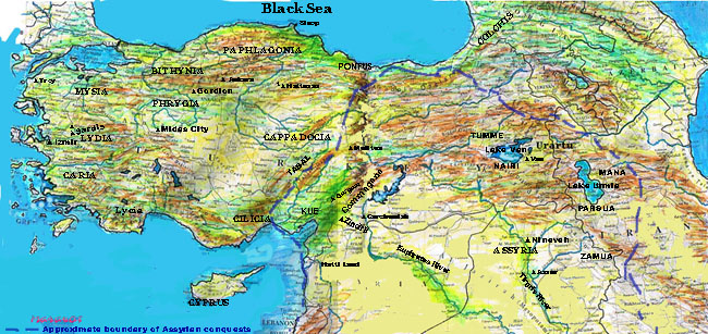
We have the Assyrian references to the Muski, Mushki, which are believed to refer to the Phrygians (a Greek designation, first recorded in the Iliad), because of the identification of the name Midas as a king of the Mushki. I don't know what the Phrygians called themselves. From the Phrygian.html it is clear that the Mushki occupied a larger territory than described by wikipedia, since Midas of Mushki held and lost in the Assyrian conquests the land in southeastern Anatolia called Kue. Kue appears to have been a "buffer" state that flipped back and forth between the Assyrians and the Mushki. The Assyrians also claim to have conquered the lands to the northwest (Tabal) and due west (Cilicia) of Kue. Kue was bordered on the northeast by Commagene and East and Southeast by the Hatti (Syrians), as near as I can discern. Kue occupies an important place in Assyrian history with regard to Assyria's conquest of Anatolia. Kue appears to have been the gateway to the interior of Anatolia (Phrygia / Mushki-land), which is why it occupied such an important position. The orthostats from Zincirli are important in this regard, since the "Sennacherib" orthostat which I identified some expert has identified as the king Panammu of Sam'al. Panammu of Sam'al is listed among the kings paying tribute to Assyria, along with the king of Kue. Thus, we know that Sam'al and Kue were two distinct kingdoms, and probably adjacent to each other. Becuase Zincirli is in a position due east of Carchemish, in a campaign through Carchemish and southern Commagene the Assyrians would need to take Zincirli, I should think.
The other orthostat from Zincirli that contains a long text should identify whether Zincirli was part of Sam'al or Kue. The text is reputed to be written in Phonecian or Aramaic, but some characters appear to be Phrygian. I can't read the text well enough from the copy I have, so the context of the longer text is up in the air in my opinion. It may hold the key to the actual extent of Phrygian territory, however.
I was surprised in my research of Egyptian texts to find a paucity of geographic knowledge with regard to Anatolia. (My hittite_treaties.html carries the texts; two others are on the Phrygian.html.) The Egyptian texts cover things the Egyptians were most interested in: The Book of the Dead (religious texts) and records of their campaigns, against the northern lands (Canaan, the Holy Land) and the Hittites. Because they clashed in Kadesh, we can suppose Kadesh, in the headwaters of the Orontes River, to be the "buffer" zone between the two empires. Recognizing this, we can understand how the Egyptian texts are somewhat mute with regard to the lands of Anatolia, except that they refer to mercenaries from Caria and Cilicia being in the Egyptian army. The context of the reference would be like the context of the Gauls serving as mercenaries in the Egyptian army. There was a large Celtic / Galic colony in the Egyptian Delta.
We do know from Herodotus that the Egyptian Pharoah Sesostris carried a campaign as far as the Hellespont, and we know from Greek legend that the ancestor of the kings of Argos came from the Nile (Danaus; he had a twin, Aegytus and they were sons of the Egyptian king Belus). Such a story is not improbable, since we know that kings' sons and daughters are sent to colonize distant lands for various reasons, from interests in forming alliances, such as the marriage between Hittites and Egyptians, or because of droughts, forcing the emmigration of peoples to more hospitable lands, or as trading outposts. In America trading outposts became forts; in Europe they became castles and walled cities grew up around them; and in the ancient world, as described by the Assyrian kings, they became castles, as at Zincirli, and walled cities. The tradition the Assyrian kings had of rebuilding "heritage" sites, raising them to the foundations, tells us something of the nature of their record process. They placed orthostats and tablets in the lowest foundations of their walls, knowing that anyone rebuilding the walls will refer to the former history of the wall recorded within it and the greatness of the king(s) and god(s) that made and preserved it.
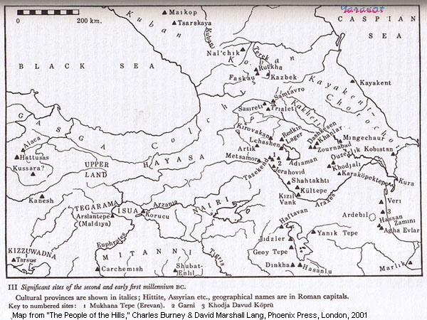
Recognizing this, we can look at the Zincirli orthostats and recognize that they are not written in cuniform. This points to a Syrian (Hittite) document (Aramaic?) and possible Phrygian context. The Assyrians recorded the Mushki in being in alliance with the nations around Nairi (the land that is most prominent in Assyrian raids). The Assyrian campaigns raided through the Upper Zab directly into Urartu / Nairi. They conducted their raids into Nairi through southern routes, usually linking through Commagene and Carchemish, where the cities of Gurgum and Melid (Militene) became important conquests. Militene was accessed through a mountain pass in northern Commagene; Gurgum might have been accessed via a route through Zincirli which is adjacent to the southeastern border of Commagene. Tiglath-Pileser III describes these cities from north to south in the context of his campaigns against Urartu (I'm reading from Phrygian.1g.html):
Sarduarri of Urartu, Sulamal of Melid (Melitene) Tarhulara [of Gurgum] ...........Kushtashpi of Kummuhu, to capture and plunder ...........between Kishtan and Halpi, districts of Kummuhu, ...........them. The river Sinzi I dyed red like wool (797).
When we examine the Assyrian texts relating to Carchemish, we see that Sargon II links it to Mitas of Muski, in a campaign working from south to north:
"allied with Mitâ ; wicked Hittites, with Kummuhu; another context: who put to flight Mitâ (Midas), king of Muski, restored the captured fortresses of Cilicia and increased their (v. its) domains...despoiler of Carchemish of the wicked Hittites, whose strong arm captured Pisiris, who was subject to them and plotted evil; who devastated Urartu"
Of interest is Assur-nasir-pal's reference to departing the land of Commagene through the pass of the goddesses (Ishtarati) and spent the night in the city of Kibaki. Several of his campaigns were along the Habur (Khabur) river which flows from Southeastern Turkey into Syria and into the Euphrates river. Alliances with Commagene included cities of the "wicked Hittites" including Hamath and Ashdod who paid tribute to Sargon II. A tribute list of Tiglath-Pileser III (See Samaria) works from the north, beginning with Commagene, grouping Kummhu, Aram, Samaria, Tyre and Byblos together and then begins in the northeast again with the group of Kue, Carchemis and Sam'al.
(Tiglath-Pileser III) The tribute of Kushtashpi of Kummhu, Rasunnu (Rezin) of Aram, Menihimmu (Menahem) of Samerina (Samaria), Hirumm (Hiram) of Tyre, Sibitti-bi'li of Gubla (Gebail, Byblos), Urikki of Kûe, Pisiris of Carchemish, Eni-ilu of Hamath, Panammû of Sam'al (772).
Zincirli seems to have had a strategic importance since Hittite times and its orthostats certainly reflect Hittite styles. Wikipedia says it is the ancient city of Sam'al:
"The German excavations on the citadel recovered large numbers of relief-carved orthostats, along with inscriptions in Aramaic, Phoenician, Luwian, and Akkadian. These are on exhibit in Berlin and Istanbul. In August 2006, the Oriental Institute of the University of Chicago began a new long-term excavation project at the site of Zincirli under the directorship of David Schloen."
The different texts are interesting in view of the fact that from the Assyrian point of view Zincirli is grouped with Kue and Carchemish. A Phrygian text would place it as the frontier of Phrygia and we know from the Assyrians that Kue was occupied by Phrygia.
Kue is discussed (See Tyre) by Sargon II in this context:
"who caught the Iamaneans (Ionians, Cyprians) out of the midst of the sea in shoals (?), like fish, and subdued Cilicia (Kue) and Tyre."
Kue appears to be a subjective guess by the translator in referring to Cilicia. But as a reference to Kue and linking it with Cyprus and Tyre we see a strategic connection as well as an alliance. Cyprus plays an important role in Egyptian trade and campaigns and it is often linked with Tyre. Linking Kue with the two would establish a common sea trade among Kue, Cypress and Tyre. In all probability the trade route was from Tyre to Cypress to a city in Anatolia, possibly Mersin, but I think there must have been a port on the Ceyhan river or the bay where it outflows (Issus?).
Tiglath-Pileser III groups Commagene again with the southern Mediterranean provinces:
"The tribute of Kushtashpi of Kummhu, Rasunnu (Rezin) of Aram, Menihimmu (Menahem) of Samerina (Samaria) "
Assur-nasir-pal describes a campaign where :
"I departed the Tigris and drew near to the land of the Kutmuhi (Commagene), I received tribute from the lands of Kutmuhi and Mushki."
Following Assyrian grouping we can view Mushki (probably Kue) bordering Commagene. That border would be Zincirli, if Mushki and Commagene during Assur-nasir-pal's time were contiguous. The Assyrian geographic descriptions tended to list places contiguous to one another.
We have another list from Tiglath-Pileser III:
The tribute of Kushtashpi of Kummuhu, Urik of Kûe, Sibitti-bi'il [of Gubla] .....[Eni]-ilu of Hamath, Panammû of Sam'al, Tarhulara of Gurgum, Sulumal of Melid] ......Uassurme of Tabal, Ushhitti of Tunai, Urballâ of Tuhan, Tuhamme of Ishtunda] (8) .....Matan-bi'il of Arvad, Sanibu of Beth-Ammon, Salamanu of Moab, ......Mitinti of Ashkelon. Iauhazi (Jehoahaz) of Judah, Kaush-malaku of Edom, Musri .....Hânûnu (Hanno) of Gaza (801)
Here the list works from north to south, begining with Kummuhu which is bordered in the southwest by Kue and southeast by Gubla (about 25 miles north of Beirut), and Hamath, then the list works in another grouping south to north: Sam'al, Gurgum, Melid, Tabal, Tunai, Tuhan, Ishtunda...
This places Sam'al north of Kue and south of Gurgum, proceeding north along the road to Melid, and north of Melid is Tabal. Tunai is of interest since it appears to be positioned at least where modern Tunceli is located. If we use this as a map, with Sam'al north of Kue, then Zincirli cannot be Sam'al. Zincirli is adjacent to the southwestern corner of Commagene, and since Kue and Commagene are adjacent to one another Zincirli must be in either Kue or Commagene.
There is much to be discovered in Midas City and Zincirli, and, of course, much to be discovered in the Zincirli texts. Since they are reputed to have been written in Akkadian (Assyrian) there should be no dispute as to the content of those texts. The Aramaic and Phonecian texts should also be clearly understood. If they mention Sam'al the place must have straddled the Taurus Mountains from Commagene to its east and Mushki on its west, with Kue to its south. I should think, however, since mountains and rivers tend to demark territories (Commagene is a good example, nestled between the bend of the Euphrates above Carchemish, the Amanus Mountains to its southwest, and the Taurus Mountains to its west.) the river valley formed by the Seyane and Ceyane Rivers would have been a continguous territory, with that area being Kue in the south and Gurgum in the north.
Arrian, or Lucius Flavius Arrianus (90-~145 A.D.) produced a history, "The Campaigns of Alexander," which records the movements of Alexander's army and that of Darius the Great in Anatolia. Of interest is the battle of Issus, which took place near Jonah's Pillar (Issus). Darius's army had been on the Euphrates plain, near the eastern side of the Amanus mountains at a place called Sochi. Arrian's Book II.4-11 tells us that after visiting Gordium and unraveling the Gordion Knot holding the yoke of King Gordius's wagon, Alexander proceeded to Ankara, in Galatia.
There appears to be an anamoly in the Gordion Knot story that should be addressed here, as it relates to the longevity of the Phrygian "nation." For about 695, 696 B.C. the Phrygian kingdom of Midas was brought down by an invasion by the Cimmerians, a Scythian tribe above the Black Sea. Here is what livius.org says about the Cimmerians and their invasion:
[livius.org] In 710/709, king Midas (Mit-ta-a according to Assyrian sources) was forced to ask for help from the Assyrian king Sargon II. However, this did not prevent the Cimmerian invasion. In 696/695, Midas committed suicide after he had lost a battle. This was the end of Phrygia, but a new kingdom arose from the ashes: Lydia. Probably, Cimmerians settled on the Phrygian plain, which was perfectly suited to their cavalry.
During the next generation, they are mentioned several times in Assyria. In 679, their leader Teušpa and his men were besieged at a town called Hubušnu. Later, they could be found near Ellipi, Media and Elam in the extreme south. The Assyrians needed much time to restore order. At the same time, another band of Cimmerians was operating to the west of Lake Van in Urartu. This group of Cimmerians seems to have moved to Cappadocia in the west, from where they attacked the new kingdom Lydia (c.665). They were repelled by king Gyges, but twenty years later, they were back and in 644, they defeated the Lydians and looted their capital Sardes. Gyges was killed by the Cimmerian leader Lygdamis (Dugdammê).During the next decade, the Cimmerians raided the Greek towns in Aeolia and Ionia, looted Paphlagonia, and captured Sinope. After 640, Lygdamis attacked Assyria twice, but was defeated. Another defeat was inflicted upon them by the Lydian king Alyattes (c.600-560), after which the Cimmerians disappear from history.
Alexander's campaign in Phrygia was in 333 B.C. This is what Arrian (~90-145 A.D.), "The Campaigns of Alexander," says about Alexander's campaign in Gordion (Gordium), the capital of Phrygia:
[Arrian, Book 1.29] Gordium is in Hellespontine Phrygia; ; the town stands on the river Sangarius, which rises in Phrygia...[Arrian Book 2.3] To return to Alexander at Gordium. Upon reaching this place he was irresitibly to visit the palace of Gordius and his son Midas high up on the acropolis, in order to inspect the famous Wagon of Gordius and the Knot with which its yoke was fixed. There was a story about this wagon, widely believed in the neighborhood. Gordius (so went the tale) lived in Phrygia in the ancient days; he was poor and had but two yoke of oxen and a small plot of land to till. With one pair of oxen he ploughed, with the other he drove his wagon. One day when he was ploughing an eagle perched on the yoke of his plough and stayed there until the oxen were loosed and the day's work done. Gordius was troubled, and went to the seers of Telmissus to consult them about what this sign from heaven might mean - for the people of Telmissus were skilled in interpreting God's mysteries, and their women and children as well as their men inherited the gift of divination. Near a village belonging to these people he fell in with a girl who was drawing water; he told her of the eagle, and she in reply, being herself sprung from a line of seers, advised him to return to the place where he had seen the sign and offer sacrifice to Zeus the King. Gordius urged her to go with him and show him the form the sacrifice should take, and he performed it as she directed, and afterwards married her, and they had a son whose name was Midas.
Now when Midas had grown to be a fine and handsome man there was trouble and strife among the Phrygians,and an oracle told them that a wagon would bring them a king, who would put an end to their quarels. While they were still debating what to do about these things, Midas with his father and mother drove up in the wagon and came to a stop at their place of meeting. Taking this to be the fulfilment of the oracle, the Phrygians decided that here was the man whom the god had foretold that a wagon would bring. So they put Midas on the throne, and he made an end of their trouble and strife and laid up his father's wagon on the acropolis as a thank-offering to Zeus the King for sending the eagle.
There was also another traditional belief about the wagon: according to this, the man who undid the know which fixed its yoke was destined to be lord of Asia. The cord was made from the bark of the cornel tree, and so cunningly was the knot tied that no one could see where it began or where it ended. For Alexander, then, how to undo it was indeed a puzzle, though he was none the less unwilling to leave it as it was, as his failure might possibly lead to public disturbances. Accounts of what followed differ: some say that Alexander cut the know with a stroke of his sowrd and exclaimed, 'I have done it!', but Aristobulus thinks that he took out th epin - a sort of wooden peg which was driven right through the shaft of the wagon and held the knot together - and thus pulled the yoke away from the shaft. I do not myself presume to dogmatize on this subject. In any case, when he and his attendants left the place where the wagon stood, the general feeling ws that the oracle about the untying of the knot had been fulfilled. Moreover, that very night there was lightning and thunder - a further sign from heaven; so Alexander, on the strength of all this, offered sacrifice the following day to the gods who had sent the sign from heaven and proclaimed the Loosing of the Knot. Next day he started for Ancyra in Galatia, where he was met by a deputation of Paphlagonians..
We note that Alexander cut the Gordion Knot over 400 years after the Cimmerians sacked Gordium and Midas committed suicide. From this testimony we can presume that the wagon was enshrined, in a temple, and there was still some continuity in the Phrygian culture. The fact that the story of Alexander cutting the Gordion Knot exists tells us that Phrygian culture was intact at the time and not virtually destroyed by the Cimmerians; also, the Lydian inheritance of Phrygia must have had marginal impact on Phrygian culture.
Alexander then proceeded to Cappadocia. Then, having received the submission of all territory bounded by the river Halys and also of a large tract to the west and north beyond it he advanced to the Cicilian Gates (Golek-Boghaz pass, the main route over the Taurus mountains between Cappadocia and Cilicia).
[Arrian, "Campaigns of Alexander" Book II.4-11] When he reached the position where Cyrus had once encamped in the campaign with Xenophon, he found the [Cicilian] Gates strongly held; so he left Parmenio there with the heavy infantry, and marched under cover of darkness to the Gates with the Guards and Agrianes, with the intention of delivering a surprise attack upon the defending force. Actually, his approach was observed, but the bold move was none the less successful; for the knowledge that Alexander was coming upon them in person was too much for the enemy, who abandoned their posts and fled. At dawn the following morning he passed the Gates with all his men and entered Cilicia, where a report reached him that Arsames had abandoned his original intention of holding Tarsus for Persia: now, it appeared, having learned that Alexander had passed the Gates, he meanto to give up the town, and the townspeople were consequently afraid that he might strip the place before he left. Alexander, accordingly, brought up his calvary and the most mobile of his light infantry with all possible speed, with the result that Arsames, the moment he was aware of his rapid appraoch, did not stop to plunder the town, but got out as fast as he could and made his way to the court of Darius. About this time Alexander had a bout of sickness. The cause of it, according to Aristobulus' account, was exhaustion, but others say that he plunged into the river Cydnus for a swim, as he was sweating with heat and could not resist the pleasure of a bath. The Cydnus runs right through Tarsus, and as it rises in Mount Taurus and flows through open country, its wares are clear and cold; the result was that Alexander was seized by a convulsion, followed by high fever and sleepless nights.
...He now dispatched Parmenio to the other Gates* which stand on the boundary between Cilicia and Assyria. Parmenio's orders were to seize and hold the pass with the troops entrusted to him - the allied infantry, the Greek mercenaries, the Thracians under Sitalces, and the Thessalian calvary. Alexander himself, leaving Tarsus after Parmenio had gone, in one day's march reached Anchialus, a town supposed to have been built by Sardanapalus the Assyrian. It is clear from the extent of the surrounding walls and the solidity of their foundations that it was originally a large town and grew to great importance. Close to the walls was the tomb of Sardanapalus, supporting a statue of him in the attitude of a man clapping his hands, with an inscription in Assyrian characters. According to the Assyrians the inscription was in verse, but whether in verse of not, the general sense of it was this: "Sardanapalus, son of Anakyndaraxes, built in one day Tarsus and Anchialus. O stranger, eat, drink, and play, for everything else in the life of a man is not worth this' - and by 'this' was to be understood a clap of the hands. They also said that 'play' wassomething of a euphemsis for the original Assyrian word.
From Anchialus Alexander proceeded to Soli, where he installed a garrison and imposed upon the town a fine of 200 talents of silver for its support of the Persian cause...He then started for Tarsus and gave orders for the calvary to proceed under the command of Philotas across the plain of Alea to the river Pyramus. With the infantry and the Royal Squadron of horse he then went to Magarsus, whence, after offering sacrifice to the local Athene, he proceeded to Mallus, where he performed all proper ceremonies in honor of the demi-god Amphilochus. In this latter place he found political troubles in progress, and settled them, remitting the tribute which the town paid to Darius on the ground that Mallus was a colony of Argos and he himself claimed to be descended from the Argive Heracleidae.
He wasstill at Mallus when a report reached him that Darius and the whole Persian army were at Sochi, a place in Assyrian territory about two days' march from the Assyrian Gates. He at once called a meeting of his staff and told them this important news. They urged unanimously an immediate advance. Alexander thanked them and dismissed the meeting, and on the following day moved forward with the evident intention of attack. Two days later he was past the Gates. He took up a position near Myriandrus, and during the night there was a storm of such violent wind and rain that he was compelled to remain where he was, with no chance of breaking camp.
Meanwhile Darius had no aparent intention of making a move; he had chosen for his position a part of Assyria where the country was flat and open, good for cavalry action, and suitable for manoeuvring the vast number under his command.
...Darius now moved; he crossed the high ground by what are called the Amanian Gates* - the pass across Mount Amanus - and, making for Issus, established himself without being perceived in Alexander's rear. Once in possession of Issus he mutilated and put to death every Macedonian he found left there as unfit for service, and on the following day moved on to the river Pinarus...When Darius received the report that Alexander was moving forward to the attack, he sent some 30,000 mounted troops and 20,000 light infantry across the river Pinarus, to give himself a chance of getting the main body of his army into position without molestation...it is on record that the army as a whole was some 600,000 strong.
...Alexander, at the head of his own troops on the right wing, rode at a gallop into the stream. Rapidity was now all in all: a swift attack would shake the enemy..the Persian left collapsed the very moment he was on them...The horses with their heavily equipped riders suffered severely, and of the thousands of panic-stricken men who struggled in hopeless disorder to escape along the narrow mountain tracks, almost as many were trampled to death by their friends as were cut down by the pursuing enemy. The Thessalians pressed the persuit without mercy, and the Persian losses in both arms, infantry, and cavalry were equally severe.
The moment the Persian left went to pieces under Alexander's attack and Darius, in his war-chariot, saw tht it was cut off, he incontinently fled - indeed, he led the race for safety. Keeping to his chariot as long as there was smooth ground to travel on, he was forced to abandon it when ravines and other obstructions barred his way; then, dropping his shield and stripping off his mantle - and even leaving his bow in the war-chariot - he leapt upon a horse and rode for his life...something like 100,000 were killed, including over 10,000 cavalry..the Macedonians in their persuit of Darius actually crossed a ravine on the bodies of the Persian dead.
...Meanwhile Darius with a few followers made the best of his escape throughout the night, and with the coming of daylight was joined as he went along by parties of survivors, Persians or mercenaries, until he had in all a body of some 4,000 men; with these he pressed on with all speed towards Thapsacus and the Euphrates with the intention of putting the river between himself and Alexander as soon as he could.
...Leaving Menon, son of Kerdimmas, as governor of Lowland Syria with the allied cavalry to keep the country under control, Alexander marched for Phoenicia...
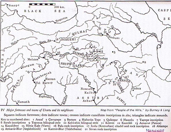
The two passes that are featured in this narrative no doubt are the two routes through Commagene that the Assyrian kings took in their campaigns. The Assyrian Gate or Belian Pass would involve campaigns against Kue, Cilicia , and perhaps Gurgum to the north. The campaigns up the Euphrates through the northern pass, the Amanian Gates, would have been against Melitea, which appears to be their entry into the lands of the Nairi (Urartu). Entry into Urartu was accessed also from the Tigris, where the armies would "cross to the other sice of the Tigris" and proceed into Nairi-land. Another route from the Tigris was through the lands of the Upper Zab which would have led directly to Lake Van.
Except for the puzzle of where the borders of Mushki/Kue (Eastern Phrygia) and Commagene met and the place where Zincirli belonged, there is not much else to do with the Phrygian.html. Arrian mentiones in Alexander's campaign a "Lesser Phrygia" which (according to asiaminorcoins.com) "stretched west along the shores of the Sea of Marmara and the Hellespont to Troas, a region afterward part of Mysia. Greater Phrygia lay farther east and inland where the Phrygian capital, Gordion (near present day Ankara) was located." Alexander marched from Gordion to Ankara and then
![]()
![]()
Phrygian1a.html
Notes:
* The "Syrian Gates," also called the "Assyrian Gates" in another place in Arrian's history. This is the Beilan pass through the Amanus Mountains, south-east of Alexandretta. Several antique prints of the pass are available online, the one linked here showing a view of the sea in the distance. From Cilicia the eastern countries could be reached by two routes, through the Syrian Gates near Alexandretta and the Amanian Gates (Bogtche Pass) in the north, leading to the Euphrates at Apamea.
4) All quotes from Assyrian texts are from "Ancient Records of Assyria and Babylonia," (in 2 volumes) by Daniel David Luckenbill, Ph.D., Professor of the Semitic Languages and Literatures in the University of Chicago, Histories & Mysteries of Man Ltd., London, 1989. Paragraph numbers used here refer to Luckenbill's numbering.
7) Paragraph 92 - drove out Mitâ, king of Muski; who restored the captured fortresses of Kue. This is an important passage. Earlier the Annals connected Mitâ of Mushki allied in the rebellion of the Manneans. Now we are told that Mitâ had held sovereignty over Que. If the Zincirli Relief is of Sennacherib and his dominion over Que, considering the Phrygian writing one would postulate that the Phrygians during the time of Sennacherib (704-681 B.C.) possessed the land of Que. The earlier statement in Sargon's Annals (721-705 B.C.) that Mitâ of Mushki held dominion over Que explains the reason for the Phrygian writing on a stone containing Sennacherib's name. This adds further evicence that at least one King Midas of Phrygia was subdued by Sargon. If this is the legendary King Midas it places him about 711 B.C., in the eighth year of Sargon's reign, at least circa. 721-705 B.C.
See also another reference to Mitâ whom Sargon "drove out" and in the same context says he (Sargon) restored the captured fortresses of Kue. This also is important since it suggests that Mitâ had taken the fortresses from Sargon.
In paragraph 99 another summary groups Kasku, all of Tabalu and Hilakku together, preceeding the description of driving out Mitâ, king of Mushki. The narrative then turns to another geographica area of conquest, beginning with the defeat of Egypt at Rapihu, counting together Hanno the king of Gaza and the defeat of the seven kings of Ia', a province of Iatnana (Cyprus) located a seven days' journey in the midst of the western sea. Recognizing that an earlier text refers to Mushki being part of Tabalu, we may surmize that the description reads from north to south, with Kasku probably being above the Halys river, near the Black Sea, Tabalu would be a region stretching from Que, on the Mediterranean coast, north to Kasku. South of Tabaluproper would be Hilakku, which must be Cilicia. To the west of Cilicia would be Lycia , Caria and Lydia, none of which are (so far as we can see) mentioned in the texts. Sandwiched to the east of Tabalu (Mushki) would be the wide region of Kummuhu which seems to begin near Carcamish and stretch to Melitea and Gurgum, the territory east of Tabalu and Mushki.
In paragraph 117 Cilicia is identified with Kue. The list of conquests involving Urartu (Armenia) begins as usual with the Medes, then westward, the Mannean-land, Urartu (Armenia), Kasku, Tabalum, up to the land of Mushki. This says that in order moving across Anatolia and northward (upwards) are the lands of Kasku, then Tabalum, all of which he conquered up to Mushki. The text identifies Melitea and Gurgum, so north of Melitea must be Kasku, and west of the region Kasku and the cities Melitea and Gurgum would be Tabalu, Tabalum and northwest of it would be Mushki.
Paragraph 442 carries an interesting link of the lands of Kutmuhi and Mushki, which were entered after crossing the Tigris from the mountains of Nipur and Pasate. He doesn't mention crossing the Euphrates, which makes this entry interesting, since the Mushki (Phrygians) would be presumed to be well to the west of the Euphrates, on the Halys river. If the Mushki are the Phrygians then we have a confirmation of their presence circa. 883-859 B.C. But here we may have a record of the Mushki being adjacent to (west of?) the Van area. Their presence there, near Urartu, would suggest the entry of the Phrygians into Anatolia (from Thrace) via the Caucaus region.
Paragraph 72, Introduction. This king, Adad-Nirâri I, provides several notations on his ancestors, in the context of honoring them for having either first built or later restored a specific structure in Assur. It was apparently the tradition to record the event on stones and bricks in the walls of the monuments with the basic who, what, when and where information successors to the long-lived dynasty would want to know. We are particularly interested i n the events leading up to the Trojan War era, circa. 1180 B.C. Because Adad-nirâri I was engaged in so much restorative work it appears that his time represented a period of peace and "restoration." After him there is a gap in the Assyrian historical record, probably caused by the same "invaders" that brought about the destruction of Hattusus and Troy. What happened between the reign of Assur-nâdin-apli, (1206-1203 B.C.) and Assur-resh-ishi I (1132-1115 B.C.)? We see in the historical record that Urartu and Commagene were viewed as land within the border of Assyria. The Assyrian kings were constantly conducting military campaigns in these areas and lands adjacent to them, and they record how the Mushki (Phrygians) and others would be allied with the rebels, which would have provoked campaigns against the Mushki. They claim to take their campaigns to the northern sea (Black Sea?), which would be a natural extension of a military campaign into the lands of the Mushki which they say are in the land(s) of Tabal. The power of the Mushki is noted in the record with regard to the disposition of Que or Kue, which they say was originally occupied by the Mushki and lost by them to Assyria, then reoccupied. If Que is another name for Cilicia it would imply that the Phrygians (Mushki) had conquered the Cilicians. We leave the issue as an occupation of Que, leaving the matter of occupation of Cilicia an unresolved matter. Adad-Nirâri I is important to the context of Phrygian influence in the sense that we can surmise that his time was a period of relative peace and not as consumed by defending the lands of Urartu (Armenia).
8) Tiglath-pileser III follows the convention of grouping districts and provinces adjacent to each other together. Such groupings tend to follow the sequence of campaigns, usually from the northwest, Urartu, to the southwest and southeast (to Kummuhu, Commagene and east to Carchemish. Within the groupings districts tend to be listed in the same order, as if one were listing cities while referring to a map. If the campaign began in the southeast, such as Tyre and worked westward, the listing would group Kummuu, west of Carchamish, and Kûe (Que) adjacent to this province, region, in the west, together. North of Kûe they list Gurgum , Melid (Melitea) and Tabal together. Following them in this group is Tunai, Tuhan and Ishtunda. Then the list shifts to Ashkelon, etc., which relates to the dominion from Egypt to Syria and the Hittite territory north of Tyre.
9) Because of the reference to the land of Nairî, we know that Tushha is Tushba (Van), the capital of the Urartu. With note 7, paragraph 442, we can inquire, whether the Mushki had moved into the region of the Tigris river (just west of it) and whether the Armanians, or Urartu, had not emerged at that time ~880 B.C.
![]()
![]() Etruscan Glossary with Phrygian words:
Etruscan Glossary with Phrygian words:
![]() Send me to Lydian.html
Send me to Lydian.html
![]() Click here for a spreadsheet of the words, Lydian Glossary.xls or Lydian_Glossary.html
Click here for a spreadsheet of the words, Lydian Glossary.xls or Lydian_Glossary.html
![]() Send me to
Send me to ![]()
Launched 6.21.07
Updated: 7.10.07; 7.12.07; 2.19.10
Copyright © 2007-2010 Maravot. All rights reserved.
Copyright © 2007-2010 Mel Copeland. All rights reserved.